|
Historic Tour of Socorro |
 |
|
|
Historic Tour of Socorro |
|
|
|
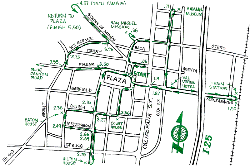
This is a leisurely, meandering ride around the town of Socorro. intended for viewing the sites in this historic town. All of the ride is on pavement, so this one is even suitable for skinny tires. If you diverge from the outlined route, you will surely find other buildings of interest wherever you explore.
Turn of the Century view of the Socorro Plaza from near the Hilton Drug Store (the oldest continuously operated business in Socorro). The old Park Hotel is in the rear -- where the Socorro Office Supply is today. The appearance of the Plaza has changed many times over the years. but has always remained central to life in Socorro.
For more information about the history of Socorro, the following books are available in the City and Tech libraries, or through the Dana Bookstore under the portal at the Val Verde Hotel.
- Of Earth and Sky. A History of New Mexico Institute of Mining and Technology 1889-1964. Paige W. Christiansen. New Mexico Institute of Mining and Technology, 1964. This 100-page book, which commemorates the 75th anniversary of the founding of the school, contains many black-and-white photographs to illustrate the text.
- Socorro. A Historic Survey. John P. Conron. University of New Mexico Press, 1980. The architectural history of Socorro, and practical applications for city planning and historic preservation, are illustrated with maps and photographs.
- Socorro Photographer: Joseph Edward Smith. 1858-1936. Compiled by John Dewitt McKee and Spencer Wilson. Socorro County Historical Society, Inc., 1974. Joseph Smith set up a photographic business in Socorro in 1884. A collection of his photographs is presented here, documenting Socorro and the mining towns nearby.
You may also contact the Socorro County Historical Society, P.O. Box 923, Socorro, NM 87801.
| Mileage | Surface | Notes |
|---|---|---|
| 0.00 | PAVED | Begin on the Plaza. The brick Hilton Block (1) on the east side, which dates from the 1880s, replaced an earlier two-story building of adobe. The California Mission-style facade on most of the plaza buildings is characterized by brick trim on the eaves, added in the early 1930s. The pharmacy on the corner was founded by a relative of hotel magnate Conrad Hilton; Desert Cycles was founded by Daniel Boone. Proceed north from the Plaza to the Title Company in the territorial-style Juan Nepomocemo Garcia house (2), with a covered veranda along its west side. This flat-roofed adobe building, which may date from the founding of Socorro in 1816, has an open central courtyard. |
| 0.06 | PAVED | Turn right onto Abeyta and go east a half block to the J. N. Garcia Opera House (3), built in 1886. Mr. Garcia died just as construction began, but his wife completed the project. The south wall has leaned outward from its earliest days, when it was used for political meetings, dances, and for grand opera. The stage is higher at the back than the front, to give the audience a better view. |
| 0.12 | PAVED | Retrace your path on Abeyta to the stop sign. The building on your right is the two-story Juan Jose Baca House and store (4), which was originally built with a flat roof, before the railroad arrived in Socorro making roofing metal easily available. |
| 0.21 | PAVED | Turn right at the stop sign and go north on Bernard, passing between crumbling adobe and brick buildings crying out for restoration. Just ahead is the San Miguel Church (5), dating from the earliest Spanish colonists. It was destroyed during the Pueblo Revolt of 1680. rebuilt in 1819-1821, restored in the 1930s and again in the 1960s. The bell towers and pitched roof were added in the mid-i 800s. |
| 0.36 | PAVED | From the church, head west on Otero Street, cross California, go one more block, and then turn left (north) on 6th Street. Follow 6th street to its end. The Hammel Museum (6) is on your right. Built by the Hammel Brothers in the 1880s as the Illinois Brewery, the business turned to ice and soft drinks during Prohibition and continued into the 1950s. The Museum hosts a yearly Oktoberfest fundraiser featuring music, dancing, food and refreshments in its rustic garden. |
| 0.71 | PAVED | From the Museum, head back south on 6th Street to Manzanares. Turn left onto Manzanares and ride to the AT&SF Railroad Depot (7) at the end of the street. The station was built in 1880 when the railroad came to Socorro. Passenger trains stopped here until the early 1970s. |
| 1.50 | PAVED | Go west on Manzanares. On the right between 5th and 6th Streets is the Val Verde Hotel (8), built in 1919 to accommodate the motor trade on the Ocean-to-Ocean Highway, the first transcontinental highway in the country. The hotel has a fine steak house in its original dining area. |
| 1.87 | PAVED | In the next block west on Manzanares is the Knights of Pythias (9) building, identifiable by the fading Owl Cigar sign on its west side, It is one of the few remaining two-story commercial buildings of the boom years, now unique in Socorro because of its cast-iron facade. The Loma Theatre (10) across thestreet from the K of P Hall, dating from the same period, was built as the Price-Loewenstein Mercantile Store. The famous Socorro County Court House from the 1890's to 1940. Behind this building was hangmans row (near mile 2.15) -- when the court failed to act fast enough, the locals did the job! |
| 1.91 | PAVED | Proceed west across California Street, back to the Plaza. Go to the far side of the Plaza and exit at the southwest corner onto Park Street. Stop at the second intersection. On the SW corner (301-303 Park) (11) is an adobe house that was partially covered with cedar shingles in the early 1900s by Joseph Smith to make his New England mother feel more at home. |
| 2.15 | PAVED | Turn right onto Church Street. The Chambon and Bursum houses at 324 and 326 Church (12, 13) were built by the same carpenter. Note the copper roof on the Bursum house, which has weathered into a green patina. |
| 2.36 | PAVED | At the west end of Church Street turn left onto Eaton. Note the Eaton House at 403 (14). After the earthquake of 1906, Mr. Eaton fortified his house by driving horizontal rods through the adobe walls, with star washers visible on the outside. The Eaton House now serves as a Bed & Breakfast. |
| 2.49 | PAVED | Now turn left on McCutcheon. This was called the French Quarter. Most of these notable houses, which date from he 1880s and early 1890s, were built to eastern tastes, with bay windows, painted picket fences, and front porches. The two-story house at 327 McCutcheon (15) is especially striking. Also note the Captain Cooney House at 309 (16). |
| 2.66 | PAVED | Stop at the corner of McCutcheon and Park. El Torreon (the old McCutcheon home) (17), a U-shaped adobe structure dating from the early 1800s was remodeled by photographer Joseph Smith. |
| 2.69 | PAVED | Turn right and go south on Park. The bungalow on the right at 405 (18) was built between 1902 and 1903 using unusual interlocking cast concrete blocks. Next on the right is the Antonio Abeyta House (19), also known as Casa de Ia Flecha (House of the Arrow), the most spectacular Victorian brick house remaining in Socorro. |
| 2.75 | PAVED | Further south, across Highway 60, at 601 Park (20) is another concrete block home. It was built by Augustus Hilton (Conrad's father) for his wife Mary. The Hiltons lived 10 miles south in San Antonio, and this house was built so Mary could live in the big city while the children attended school. (If you continue south on Park, you will go to the Socorro County Fair Grounds, but for this tour turn around and retrace your route on Park Street to Church Street.) |
| 3.27 | PAVED | Turn right on Church. On the right is the pueblo-revival style Socorro County Courthouse (21), built in 1940. It replaced an earlier Victorian building that is featured on local posters. |
| 3.36 | PAVED | Go north from the Courthouse back to the Plaza. On this third and last leg of the tour, go west on Fisher Street. |
| 3.50 | PAVED | On the right is a stone building (22) built in the early 1900s that originally housed the city water department. Until a few years ago it served as the City Police station. A little further along on the right at 225 Fisher (23) is a nicely restored historic adobe bungalow. |
| 3.55 | PAVED | Proceed west to the stop sign at Grant Street. Straight ahead is Blue Canyon Road, the original route through Blue Canyon to the town of Magdalena. Instead of going to Magdalena, turn right (north) onto Grant. |
| 3.73 | PAVED | One block later, turn right (east) onto Mt. Carmel, which also has a number of old houses. The Stapleton House at 313 Mt. Carmel (24), built in the 1880s, has been restored. |
| 3.96 | PAVED | At the stop sign at School of Mines Road, turn left. This is the road to New Mexico Institute of Mining and Technology, founded in 1890 as the New Mexico School of Mines (25). |
| 4.57 | PAVED | The school is at the end of School of Mines Road. The oldest remaining building on the campus is the central part of Cramer Hall (1928), which is one year older than Brown Hall, which houses administrative offices. Many of the buildings were built in the 1930s by the WPA. After you have explored the green oasis that is the campus, return to the Plaza via School of Mines Road. |
| 5.50 | PAVED | Back at the Plaza. The Capital Bar was struck by lightning and gutted by fire in August 1993. |