Trails

Socorro Fat Tire Trails

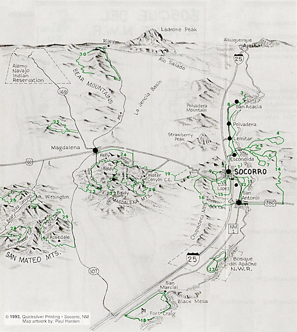
There is a wide, wonderful variety of trails in and around the Socorro area. Short easy trails let you explore the town and the foothills of the surrounding mountains; longer, moderate trails offer a jaunt along the river or between the irrigated farmlands; and more difficult trails up and down the hills, and through the canyons and sandy arroyos offer challenges to the most skilled riders.

Socorro's fat tire trails are spread out all over the county, with new trails being developed on a regular basis. Perhaps the easiest way to get acquainted with what Socorro has to offer is to use the area map. Alternately, you can peruse the full list of trails by name, by difficulty, or by length.

Before you go, please check out the additional information presented in our overview--especially the section on safety. We strongly suggest that ANSI or SNELL approved hard-shell helmets be worn on all rides (some rides even warrant body armor)! You are also encouraged to bring sunscreen, bug repellent, plenty of water, and any food or medical items you might need. Mountain biking in the high desert is an incredible experience, but requires special preparation.

A Word About Trail Ratings

The Fat Tire Trail Guide offers a wide range of trails, from short to near epic, and from leisurely romps along paved roads to "I'm gonna die" descents. Obviously, not all rides are suitable for all riders. In order to help you choose trails which match your personal skill and fitness levels, we classify our rides by their length, elevation, and subjective skill level. From these we distill, via a secret formula protected by highly-trained roadrunners, an overall "difficulty" rating.

All of these metrics run on scales from 1 to 5: "1" means that anyone who can physically climb onto a bike (or push it, for that matter) should be able to do it; "5" means that anyone who isn't very good at riding will be miserable, and may well hurt themselves in the attempt.

1 (Easy) 2 3 (Moderate) 4 5 (Hard)

We assume that a beginning mountain biker will start with the easy to moderate rides. Generally, the moderate to difficult rides require strong aerobic conditioning, and technical riding skills to negotiate steep and challenging terrain.

Please be honest with yourself. We really don't want to see anyone get hurt.

Er, Make That a Right Turn...

We've made every effort, spent countless hours riding trails, and had far too many sleepless nights ensuring that this guide is accurate and comprehensive. Alas, perfection is not human nature. If you find an error in one of our trails (and we're sure you will), or simply have a suggestion, please let us know.

Don't See Your Favorite Trail?

Do you have a favorite fat tire trail which is not listed in this guide? We'd love to hear about it! This trail book is a work in progress (and probably always will be--sigh): additional legal trails are always welcome. Just drop us a line, and we'll work something out.

Area Map

Regions

FIX ME!

Trails By Difficulty

Trail Name Fitness Rating Skill Rating Length
Bosque del Apache 1 1 11.9 mi
Escondida Lake 1 1 11.5 mi
Historic Tour of Socorro 1 1 5.5 mi
Piro Indian Ruins 1 1 10.5 mi
Socorro to Escondida Bridge 1 1 5.6 mi
Two Loops East of Socorro 1 1 5.3 mi
East Slopes of the Magdalenas (Jordan Canyon to Six-Mile Canyon) 3 1 16.0 mi
Fort Craig to San Marcial 3 1 20.0 mi
Mission Loop 3 1 25.4 mi
San Acacia Rock Art and Dam 3 1 35.0 mi
San Antonio on Ditch Roads 3 1 25.0 mi
Shrine Loop 3 1 21.2 mi
Socorro Isopods and Sedillo Springs 1 3 6.6 mi
Barite Mine and Box Canyon 3 3 17.4 mi
Bursum Springs 3 3 25.6 mi
Cerrillos del Coyote 3 3 12.2 mi
Gallinas Canyon Ruins 3 3 31.7 mi
Johnson Hill 3 3 27.5 mi
Mill Canyon to Hop Canyon 3 3 16.0 mi
Morine and Durfee Canyons 3 3 16.1 mi
Riley Loop 3 3 17.0 mi
Water Tower 3 3 9.2 mi
White Water and Big Pigeon Canyons 3 3 24.4 mi
Quebradas Back Country Byway 5 1 55.0 mi
Mt. Withington 5 3 12.6 mi
Nogal Canyon 5 3 38.6 mi
Big Rosa Canyon 5 5 27.7 mi
Jordan Canyon - North Baldy - Kelly 5 5 35.0 mi
Magdalena Mountains Trail 11 5 5 11.9 mi
Six-Mile Canyon 5 5 13.6 mi
South Baldy to North Baldy and Jordan Canyon 5 5 14.0 mi

Trails By Length

Trail Name Fitness Rating Skill Rating Length
Two Loops East of Socorro 1 1 5.3 mi
Historic Tour of Socorro 1 1 5.5 mi
Socorro to Escondida Bridge 1 1 5.6 mi
Socorro Isopods and Sedillo Springs 1 3 6.6 mi
Water Tower 3 3 9.2 mi
Piro Indian Ruins 1 1 10.5 mi
Escondida Lake 1 1 11.5 mi
Bosque del Apache 1 1 11.9 mi
Magdalena Mountains Trail 11 5 5 11.9 mi
Cerrillos del Coyote 3 3 12.2 mi
Mt. Withington 5 3 12.6 mi
Six-Mile Canyon 5 5 13.6 mi
South Baldy to North Baldy and Jordan Canyon 5 5 14.0 mi
East Slopes of the Magdalenas (Jordan Canyon to Six-Mile Canyon) 3 1 16.0 mi
Mill Canyon to Hop Canyon 3 3 16.0 mi
Morine and Durfee Canyons 3 3 16.1 mi
Riley Loop 3 3 17.0 mi
Barite Mine and Box Canyon 3 3 17.4 mi
Fort Craig to San Marcial 3 1 20.0 mi
Shrine Loop 3 1 21.2 mi
White Water and Big Pigeon Canyons 3 3 24.4 mi
San Antonio on Ditch Roads 3 1 25.0 mi
Mission Loop 3 1 25.4 mi
Bursum Springs 3 3 25.6 mi
Johnson Hill 3 3 27.5 mi
Big Rosa Canyon 5 5 27.7 mi
Gallinas Canyon Ruins 3 3 31.7 mi
Jordan Canyon - North Baldy - Kelly 5 5 35.0 mi
San Acacia Rock Art and Dam 3 1 35.0 mi
Nogal Canyon 5 3 38.6 mi
Quebradas Back Country Byway 5 1 55.0 mi

Trails By Name

Trail Name Fitness Rating Skill Rating Length
Barite Mine and Box Canyon 3 3 17.4 mi
Big Rosa Canyon 5 5 27.7 mi
Bosque del Apache 1 1 11.9 mi
Bursum Springs 3 3 25.6 mi
Cerrillos del Coyote 3 3 12.2 mi
East Slopes of the Magdalenas (Jordan Canyon to Six-Mile Canyon) 3 1 16.0 mi
Escondida Lake 1 1 11.5 mi
Fort Craig to San Marcial 3 1 20.0 mi
Gallinas Canyon Ruins 3 3 31.7 mi
Historic Tour of Socorro 1 1 5.5 mi
Johnson Hill 3 3 27.5 mi
Jordan Canyon - North Baldy - Kelly 5 5 35.0 mi
Magdalena Mountains Trail 11 5 5 11.9 mi
Mill Canyon to Hop Canyon 3 3 16.0 mi
Mission Loop 3 1 25.4 mi
Morine and Durfee Canyons 3 3 16.1 mi
Mt. Withington 5 3 12.6 mi
Nogal Canyon 5 3 38.6 mi
Piro Indian Ruins 1 1 10.5 mi
Quebradas Back Country Byway 5 1 55.0 mi
Riley Loop 3 3 17.0 mi
San Acacia Rock Art and Dam 3 1 35.0 mi
San Antonio on Ditch Roads 3 1 25.0 mi
Shrine Loop 3 1 21.2 mi
Six-Mile Canyon 5 5 13.6 mi
Socorro Isopods and Sedillo Springs 1 3 6.6 mi
Socorro to Escondida Bridge 1 1 5.6 mi
South Baldy to North Baldy and Jordan Canyon 5 5 14.0 mi
Two Loops East of Socorro 1 1 5.3 mi
Water Tower 3 3 9.2 mi
White Water and Big Pigeon Canyons 3 3 24.4 mi