|
Escondida Lake |
 |
|
|
Escondida Lake |
|
|
|
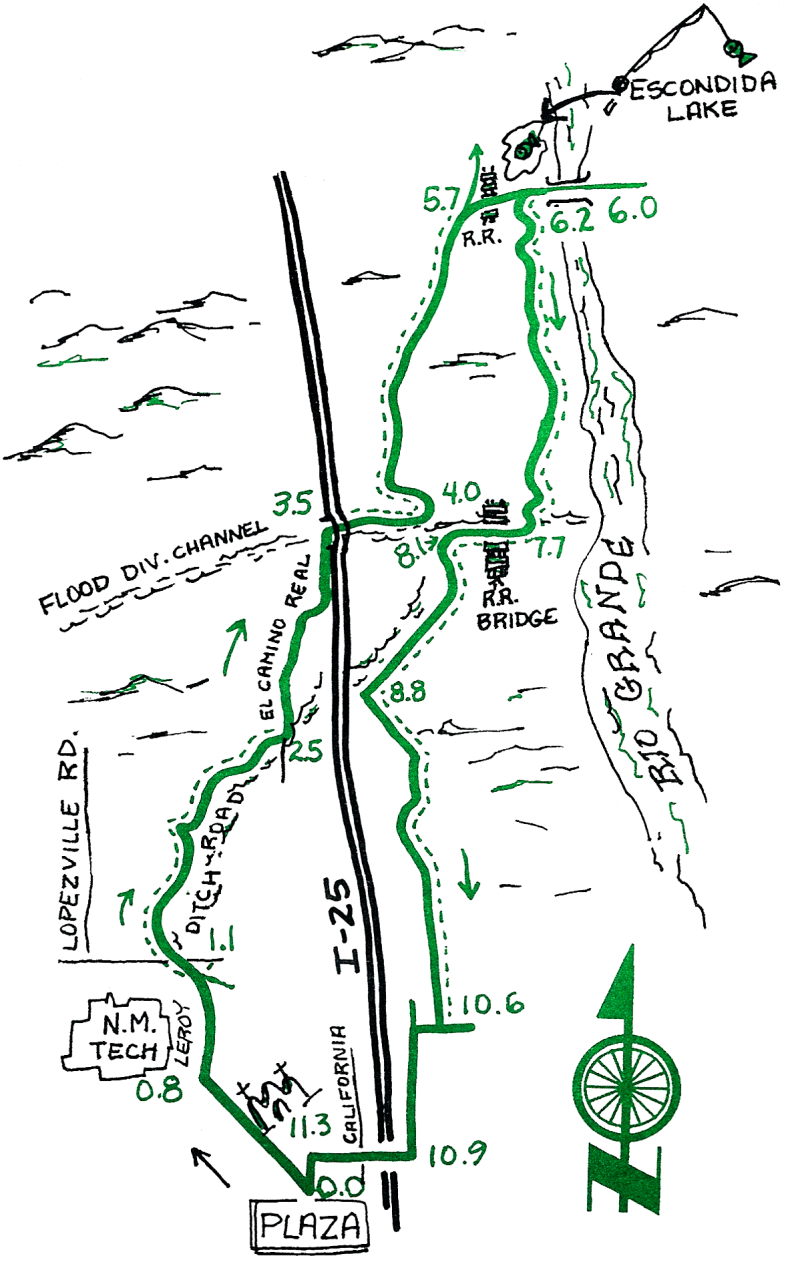
This is an enjoyable ride that we like to do before work in the morning. It's a slightly more circumspect route than Ride #1. Enjoy the unhurried farms in the Rio Grande Valley. In the winter there are often sand- hill cranes here. Crossing the Flood Diversion Canal only seems hard until you do it.
| Mileage | Surface | Notes |
|---|---|---|
| 0.0 | PAVED | Plaza. Head northwest on School of Mines Road toward the New Mexico Tech Campus. |
| 0.8 | PAVED | Turn right onto Leroy Avenue. |
| 1.1 | DIRT | At the end of Leroy. get on the ditch bank road and go left (north). |
| 1.6 | DIRT | A short detour onto a paved street, then back to the ditch road, heading mainly north. |
| 2.5 | PAVED | Turn left (north) onto the next paved street. El Camino Real. Continue north even after there are no more houses and the pavement turns into a series of dirt tracks (continue to head mainly north) that eventually head to the Flood Diversion Channel. |
| 3.5 | DIRT | Flood Diversion Channel: ride down the cement side at an angle, as opposed to straight down (it's easier than it looks), and back up the other side. Go under 1-25 |
| 4.0 | DIRT | Get off the road along the concrete channel after the 1-25 bridge; turn left (north) onto the east bank of the irrigation ditch. |
| 5.6 | DIRT | Switch to the west bank. |
| 5.7 | PAVED | Turn right and follow the paved road east |
| 5.9 | PAVED | Escondida Lake is on the left, a popular fishing spot. |
| 6.0 | PAVED | Rio Grande Bridge. We will turn around here. To the east there are hundreds of miles of old roads to explore. |
| 6.1 | PAVED | A small detour to the right just past the lake road takes you to a fun steep descent on the left where "real men" test their pick-up trucks. |
| 6.2 | DIRT | Head south before crossing the RR tracks. |
| 7.7 | DIRT | Go up the little hill to your right and cross the bridge over the Flood Canal. Immediately head west on the high bank on the south side of the Flood Control Channel. |
| 8.1 | DIRT | Follow the irrigation ditch south on the left bank. |
| 8.8 | DIRT | Turn left, change ditches, and continue south on the left bank. |
| 10.6 | PAVED | Detour onto the frontage road and go left (south) to Otero Street. |
| 10.9 | PAVED | Go right (west) on Otero, under California Street, under the interstate, and accross at the light. |
| 11.3 | PAVED | San Miguel Mission. Turn left and continue to |
| 11.5 | PAVED | The Plaza. |