|
San Acacia Rock Art and Dam |
 |
|
|
San Acacia Rock Art and Dam |
|
|
|
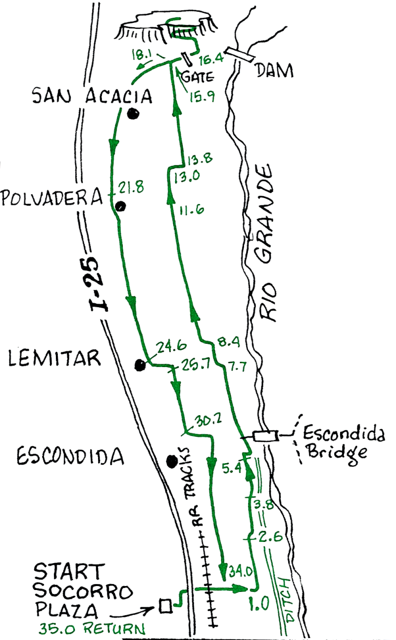
This is a pleasant ride through farms and bosque in the Rio Grande Valley. Follow one of the irrigation ditches on the east side of town to start the journey north. As you continue north you will notice server ditches with their water coming from the north. If you get confused as to which ditch to take, keep in mind that they all originate at San Acacia Dam. To return, you can retrace your tracks, or follow the main Diversion Channel back south, or take old Route 85 through Polvadera. Lemitar, and Escondida.
| Mileage | Surface | Notes |
|---|---|---|
| 0.0 | PAVED | Starting at the Plaza. go east on Manzanares and turn left onto Califomia Street at the traffic light. At the next light turn right onto Otero, under I-25, over the RR tracks, and continue straight as the road turns to dirt. |
| 1.0 | DIRT | Turn north (left) onto the first ditch road that you come to |
| 2.6 | DIRT | End of Jaral Ditch; continue north (left) on the west bank of this larger ditch. |
| 3.8 | DIRT | Go up the hill, over the bridge, bear slightly right, and continue north with the ditch on your right and fields to your left. |
| 5.4 | PAVED | Turn right onto the paved road. On top of the hill turn north (left) and ride along the west side of the Main Channel. |
| 7.7 | DIRT | At the Diversion Station go left onto the east side of a smaller ditch, and head north. |
| 8.4 | DIRT | Jog to the left onto the west side of the ditch; continue north. |
| 11.6 | PAVED | The ditch road meets paved Farm Market Road. Continue north. |
| 13.0 | DIRT | At the bend just before the railway track, turn right onto the east side of a large ditch. |
| 13.8 | DIRT | Go left over the ditch and RR tracks, and continue north on the west side of the ditch. |
| 15.9 | PAVED | Intersection with paved San Acacia Road, which you can use on the return trip if desired. Continue north to the flat mesa ahead. |
| 16.4 | PAVED | Gate. If locked, lift your bike over. (The gate and "No Trespassing signs are to keep fishermen out.) |
| 16.5 | DIRT | Bear to the left up the rocky road. Pictographs and Indian ruins can be found on the rocks around the east edge and on top of the mesa. Please respect the private property and don't collect or disturb cultural artifacts. WATCH OUT FOR RATTLESNAKES in the summer. The dam is to your right. If you want to continue all the way around the mesa, it can be done with a little pushing. |
| 18.1 | PAVED | Backtrack on the paved road, through the town of San Acacia to the Interstate, and head south on the east frontage road. |
| 21.8 | PAVED | Bear left to the town of Polvadera "dusty" in Spanish). |
| 24.6 | PAVED | Bear left into the town of Lemitar, taking County Road 5. |
| 25.7 | PAVED | General Store. Go left at the stop sign and right at the Post Office, after a couple of hundred yards, and continue south. |
| 30.2 | DIRT | Escondida. Continue straight to the Flood Control Channel, east to the bridge, and south back toward Socorro. |
| 34.0 | DIRT | Turn right on the gravel road (Otero Street) and continue east to San Miguel Mission where you turn left toward the Plaza. |