|
Johnson Hill |
 |
|
|
Johnson Hill |
|
|
|
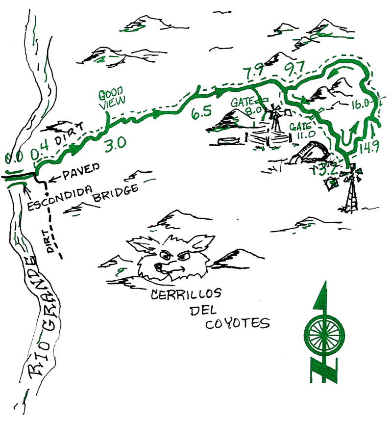
The initial climb up Johnson Hill is steep, but not too long. The view changes as you move away from the river valley. There are canyons, hidden valleys, old ranches, and more surprises. The less-traveled roads will be a fun challenge to the intermediate rider; the uphill grade will give everyone an aerobic workout.
| Mileage | Surface | Notes |
|---|---|---|
| 0.0 | PAVED | Escondida Bridge (reset your odometer to 0 if you got here by bike). |
| 0.4 | DIRT | At the T intersection, go left on the dirt road (the paved road goes right). |
| 3.0 | DIRT | Go north a short distance to the end of the side road for a great view, and then return to this point and continue on. |
| 6.5 | DIRT | Junction with signs. Take the right fork and head east. |
| 7.9 | DIRT | We will take a right on this side road for a side-trip to the ruins of a turn-of-the century ranch and old well. |
| 8.0 | DIRT | Go through the gate. |
| 8.3 | DIRT | Look around the ruins, and head back to the main road. |
| 8.6 | DIRT | This is the main road. Turn right and continue east, as before. |
| 9.7 | DIRT | Turn right on a small side road and head southeast. |
| 10.6 | DIRT | Pass by an old windmill. |
| 10.7 | DIRT | Spring. Go up the arroyo 100 ft., then right on the road on the other side. |
| 11.0 | DIRT | Go through the gate and close it afterwards. |
| 12.9 | DIRT | Dead refrigerator. Was it used once as a cattle feeding trough? |
| 13.2 | DIRT | Go left at the junction just before the windmill, and head northeast. |
| 13.5 | DIRT | Crest of the hill. Great views of the Sierra de Ia Cruz. |
| 14.9 | DIRT | Junction with main road. Turn left and head west. |
| 16.8 | DIRT | Check out the remains of this old ranch. |
| 18.9 | DIRT | Pass the turnoff you took (mile 9.7). Follow the main road back to the bridge. |
| 27.5 | DIRT | The Bridge. |