|
Bursum Springs |
 |
|
|
Bursum Springs |
|
|
|
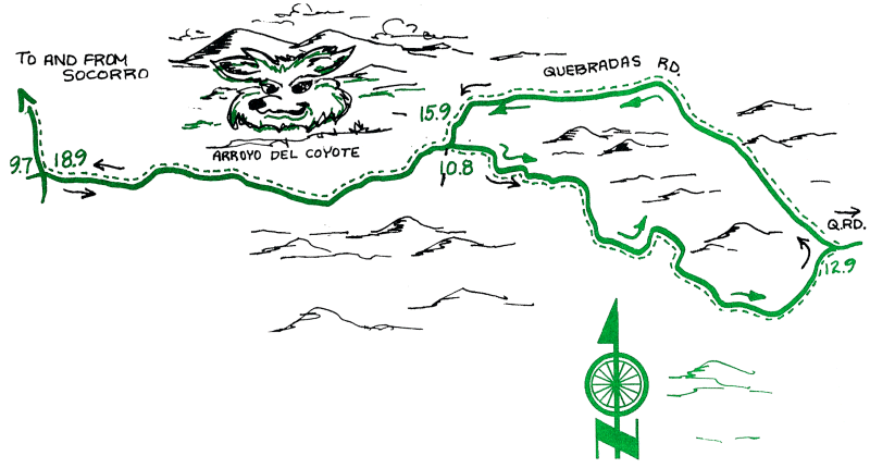
This ride to the east of Socorro uses the same approach as the Quebradas Back Country Byway ride, but follows portions of the historical predecessor to the Quebradas Road. It can be ridden as a shorter (6.2 mile) ride by beginning at mile 9.7. The loop returns to that point at mile 15.9. The route passes areas once used for mining and still used for ranching. The loop portion of the ride is on an unmaintained road and along arroyo bottoms where sand may represent a challenge in places. Topography is hilly with some short, steep climbs and descents. The ride does cross private land for which we have permission to enter. This permission may be revoked thereafter. Respect signs and locked gates.
| Mileage | Surface | Notes |
|---|---|---|
| 0.0 | PAVED | From the Plaza, follow the directions for GUEBRADAS BACK COUNTRY BYWAY as far as Mile 6.7 (just over the bridge). |
| 6.7 | DIRT | "Y" intersection; turn left (east). The Quebradas Road is marked by a sign. The road may be washboard, but it will smooth out shortly. |
| 9.7 | DIRT | "Y" intersection; bear right, departing the main (Quebradas) road onto a less traveled road. |
| 10.4 | DIRT | Cattle pens and spring on left. This is on private property. |
| 10.7 | DIRT | Cable crosses road; end of private property. |
| 10.8 | DIRT | "Y" intersection; bear right. |
| 10.9 | DIRT | Y intersection; bear right again. |
| 12.3 | DIRT | Climb out of arroyo onto the road to the left. |
| 12.7 | DIRT | A small arroyo cuts the road here. |
| 12.8 | DIRT | The route rejoins the Quebradas Road; turn left. |
| 15.9 | DIRT | "Y" intersection; bear right. This is the point where the loop originally departed from the Quebradas Road. |
| 18.9 | DIRT | "Y" intersection; bear right (north). The road parallels the Rio Grande. |
| 20.3 | PAVED | Recross the Rio Grande Bridge. |
| 20.5 | DIRT | Turn south onto the dirt (not gravel) ditch-bank road; the irrigation ditch will be on your left. As the road nears the big flood-control ditch (in about 1.5 mi.), jog right then left at the top of the ditch-bank to cross the wooden bridge. |
| 22.1 | PAVED | Cross the bridge over the flood-control ditch, turn right (downhill) onto pavement heading west. The road shortly turns left (south). Proceed along the frontage road (past El Sombrero Restaurant) to the stop sign at Otero Street, where you turn right. Cross California Street at the light, turn left at San Miguel Church (Bernard Street). The Plaza is directly ahead. |
| 25.6 | PAVED | Socorro Plaza! |