|
San Antonio on Ditch Roads |
 |
|
|
San Antonio on Ditch Roads |
|
|
|
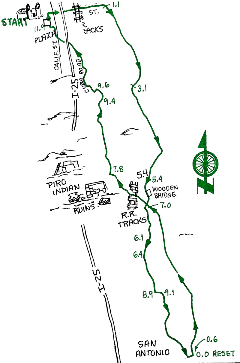
Ride to San Antonio and back by way of irrigation ditch-bank roads. The route south goes through farm and ranch country, and the return leg follows the Bosque Drainage Canal and an irrigation ditch. Old State Route 1 or the Farm-to-Market Road may also be used to return to Socorro. There are several places in San Antonio to eat (the famous Owl Bar is closed on Sundays) or snack. The Bosque del Apache Wildlife Refuge is 10 miles south of San Antonio.
| Mileage | Surface | Notes |
|---|---|---|
| 0.0 | PAVED | Plaza. Take Bernard Road north toward San Miguel Mission, where you turn right onto Otero Street. Continue east on Otero, across California Street, under the Freeway, over the RR tracks, and continue straight as Otero becomes a dirt road. |
| 1.1 | DIRT | Turn right on the west side of the first main irrigation ditch at the edge of the fields. Listen for peacocks calling from a nearby roof. |
| 3.1 | DIRT | Go left over the ditch to the treeline and continue south. |
| 5.4 | DIRT | Zig to the right, over the ditch, continue south over the wooden bridge, and zag left to the west side of the ditch. Continue south. |
| 6.1 | DIRT | Bear right at the "Y" |
| 6.4 | DIRT | Cross the paved road, and take the road on the east ditch bank. |
| 8.3 | DIRT | Continue south at the "Y'. |
| 8.9 | PAVED | Turn left on the paved road (Sam's Place). |
| 9.1 | DIRT | Turn right and take the east side of the ditch heading south. |
| 11.7 | DIRT | Take a right on the paved road that leads to US 380. |
| 12.2 | PAVED | Turn right onto US 380; head west to the center of San Antonio. |
RETURN TO SOCORRO (Reset your odometer) |
||
| 0.0 | PAVED | From the Owl Bar and Cafe head east on US Highway 380. |
| 0.6 | DIRT | Turn left onto the east side of the second ditch, next to the power pole. After 1/4 mile, get on top of the levy, and continue north. |
| 7.0 | DIRT | Head west past the bridge (don't cross over it), jog left then immediately right, toward the mountains, and continue west over the RR tracks. |
| 7.8 | DIRT | Turn right on the west side of the ditch, next to the bluffs, and continue north. Note: There is a Piro Indian ruin on the hill to the NW (see PIRO ride). |
| 9.4 | DIRT | Go up and over two levies, north through the gate (at mile 95). Close it after you. |
| 9.6 | DIRT | At the "T" intersection, go left on the dirt road, then the next right on Cuba Road (mile 9.7), which you can follow back to California Street and to... |
| 11.9 | PAVED | The Plaza. |