|
Piro Indian Ruins |
 |
|
|
Piro Indian Ruins |
|
|
|
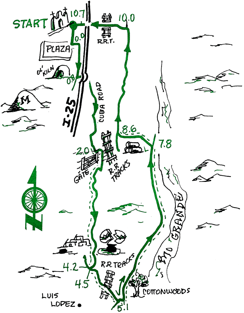
This easy ride features a visit to an unexcavated site of a Piro Indian Pueblo on top of a bluff overlooking the Rio Grande Valley, where it was safe from floodwaters. If you find pottery shards on the ground, you may pick them up to look (use your water bottle to rinse off the dust), but please don't remove them from the site. Leave all artifacts where you find them.
| Mileage | Surface | Notes |
|---|---|---|
| 0.0 | PAVED | Starting at the Plaza, go east on Manzanares and turn right onto California Street at the traffic light. Turn left onto Meek Street just past the RR tracks. Meek becomes Cuba Road as it goes under the Interstate. |
| 0.8 | PAVED | Just before you go under the Interstate on Cuba Road you will see the stone remains of an old kiln, left from Socorro's mining days. Stay on the pavement (such as it is!) and follow Cuba Road as it eventually turns to dirt and meanders along the base of the bluffs. |
| 1.9 | DIRT | Cuba road ends in a T intersection, where you turn left. In 50 yards (don't go over the RR track) turn right onto a dirt road that enters private land. Cross the cattle guard, and close the gate (even if you found it open). Head south with the ditch on your left. |
| 4.0 | DIRT | At the junction turn to the right (west); don't follow the main road, but do follow the small track that goes northwest up the bank to the BLM sign. The passage in the fence marks the entrance to the ruins. Park your bike and walk northward, keeping your eyes to the ground for remnants of stone pueblo walls and pot shards. Please do not disturb the ruins. It's okay to look, but it's illegal to remove anything you may find. |
| 4.3 | DIRT | From the ruins retrace your path back to the road at the base of the mesa. At the junction, you head east (don't go back north on the road you came on). |
| 4.9 | DIRT | Multiple junction of roads and ditches; go left (north) over the old wooden bridge and take the highest, biggest road north. Cottonwoods and the bosque are on your right. |
| 7.4 | DIRT | Junction (pile of big cement pipes suitable for being climbed upon); head northwest along the ditch, directly toward M-Mountain. |
| 8.4 | PAVED | Junction; head right (north) on gravel that soon becomes paved. |
| 9.6 | PAVED | Junction, head left (west) into Socorro on Otero Street, over the RR tracks and across California Street at the traffic light. |
| 10.2 | PAVED | At San Miguel Mission turn south and head for the Plaza. |
| 10.5 | PAVED | You have returned to the Plaza. |