|
Quebradas Back Country Byway |
 |
|
|
Quebradas Back Country Byway |
|
|
|
||||||||||||||
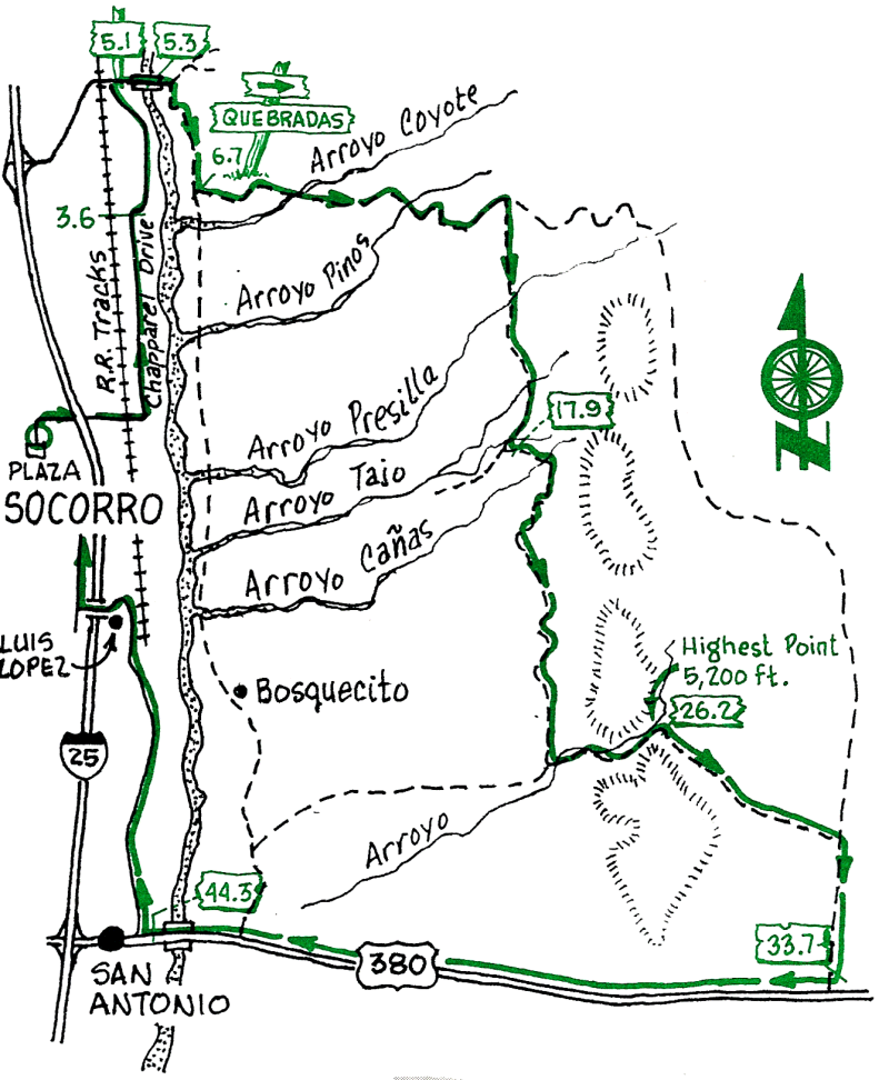
This is a long but enjoyable ride through some very interesting and beautiful desert country. The road is a wide one-lane dirt road suitable for regular cars in good weather (because of the mud the road should be avoided during and soon after a rain). There are a few steep sections but most of the route has only a small gradient. Hazards include loose rocks on the road, dried ruts, and the one or two cars you will see all day. Take sunscreen, a snack, and plenty of water. There is no shelter or shade along most of this route.
| Mileage | Surface | Notes |
|---|---|---|
| 0.0 | PAVED | From the Plaza head north on Bernard Road; turn right at San Miguel Church onto Otero Ave.; continue east across California Street (through the light). Go under the Interstate, past the sewage treatment plant, cross the RR tracks, and turn left (north) onto Chaparral. |
| 3.6 | DIRT | Climb up onto the flood-control ditch bank, and cross it on the bridge. Take a brief jog to the right onto the dirt road and immediately head north (fields to your left and irrigation ditch to your right) |
| 5.1 | PAVED | Turn right (east) onto the narrow paved road. Catch a glimpse of Escondida Lake, on your left. |
| 5.3 | PAVED | Cross the Rio Grande on a bridge (civilized!); during mid-summer the river is sometimes a bed of dry sand. Continue east on pavement to the T intersection, where you turn right (south); the paved road takes a little jog to the left and becomes dirt. |
| 6.7 | DIRT | Turn left (east); the Quebradas Road is marked by a sign saying "Back Country Byway." The road may be washboard here, but it will smooth out in a mile or so. |
| 17.9 | DIRT | Junction; follow the Back Country Byway sign and go left (east). |
| 26.2. | DIRT | This pass is the highest point on the ride. |
| 33.7 | PAVED | Turn right (west) onto US Highway 380. It's mostly downhill from here to the town of San Antonio, birthplace of Conrad Hilton. |
| 44.3 | PAVED | The flashing traffic light marks the center of metropolitan San Antonio. Stop in town for a world-famous green-chile cheeseburger (closed on Sundays) or for homemade fudge. You can head north on the pavement at the traffic light on State Highway 1, which will cross over the Interstate at Louis Lopez and continue north to Socorro, or you can follow one of the ditch-bank roads (see SAN ANTONIO ride, half on pavement, half on dirt). |
| 55.0 | PAVED | You're back at the Socorro Plaza |