|
Nogal Canyon |
 |
|
|
Nogal Canyon |
|
|
|
||||||||||||
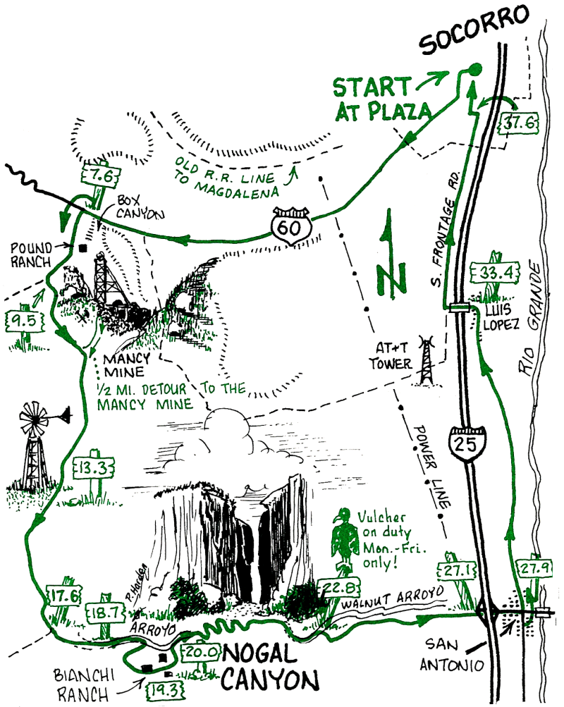
This is an interesting route in the hills, canyons, and rangeland west and south of Socorro. It also can be driven if you have a high-clearance 4x4, but it is better on a bike. Take plenty of water, and be aware that the narrow, steep-sided arroyo has a history of severe flash floods following local thunderstorms.
| Mileage | Surface | Notes |
|---|---|---|
| 0.0 | PAVED | Plaza. Head west up Fisher Street to the stop sign at Grant Street. Turn left onto Grant, then right at the next stop sign and continue on this road as it becomes Hwy 60 heading west. |
| 7.6 | DIRT | About 0.1 mile after crossing a deep canyon, turn left (south) on the dirt road. This area, called Box Canyon, is a favorite of local rock climbers. Continue south on the dirt road, with low hills paralleling the road on both sides. |
| 8.5 | DIRT | Ranch. Continue south. |
| 9.5 | DIRT | Turn left at the junction. |
| 9.7 | DIRT | Bear right at the junction; continue south. Look down the road to the left and you can see the head-frame to the old Mancy Mine. It's a 0.5-mile detour if you investigate. |
| 13.3 | DIRT | Windmill. |
| 17.6 | DIRT | Junction with signs. Head east (left) toward the Bianchi Ranch. |
| 18.7 | SAND | Head down the arroyo for 0.5 miles. This sand is just a mild preparation for what's yet to come! |
| 19.3 | DIRT | Old ranch: Bianchi Headquarters. The ranch house was burned only recently, although it has been uninhabited for a number of years. This is a good rest stop; explore the ruins and the arroyo with its spring, but please respect this private property. |
| 20.0 | SAND | Continue down the road, which follows the arroyo. The canyon becomes narrow and deep. |
| 22.8 | DIRT | Out of the sand and up a hill heading south. At the top the road continues east as it descends into the Rio Grande Valley. |
| 27.1 | PAVED | Highway I-25. Go under the interstate, and east into the town of San Antonio, birthplace of hotel entrepreneur Conrad Hilton. |
| 27.9 | PAVED | Try a Green Chile Cheese Burger at the Owl Bar (closed on Sundays). Then, from the flashing traffic light, head north (turn left) on the paved road. (See the return leg of the SAN ANTONIO ride for alternate routes back to Socorro using ditch roads.) |
| 33.4 | PAVED | The town of Luis Lopez. The paved road briefly curves to the west to cross the Interstate; turn right (north) at the stop sign on the other side of 1-25. |
| 37.6 | PAVED | Turn left just past the campground-RV Park, go a short block, then turn north (right) onto Fairground Road. This becomes Park Street and leads directly to the Plaza (although you must take a jog to the right at the adobe County Courthouse to avoid going the wrong way on a one-way street for the last block). |
| 38.6 | PAVED | The Plaza! |