|
Six-Mile Canyon |
 |
|
|
Six-Mile Canyon |
|
|
|
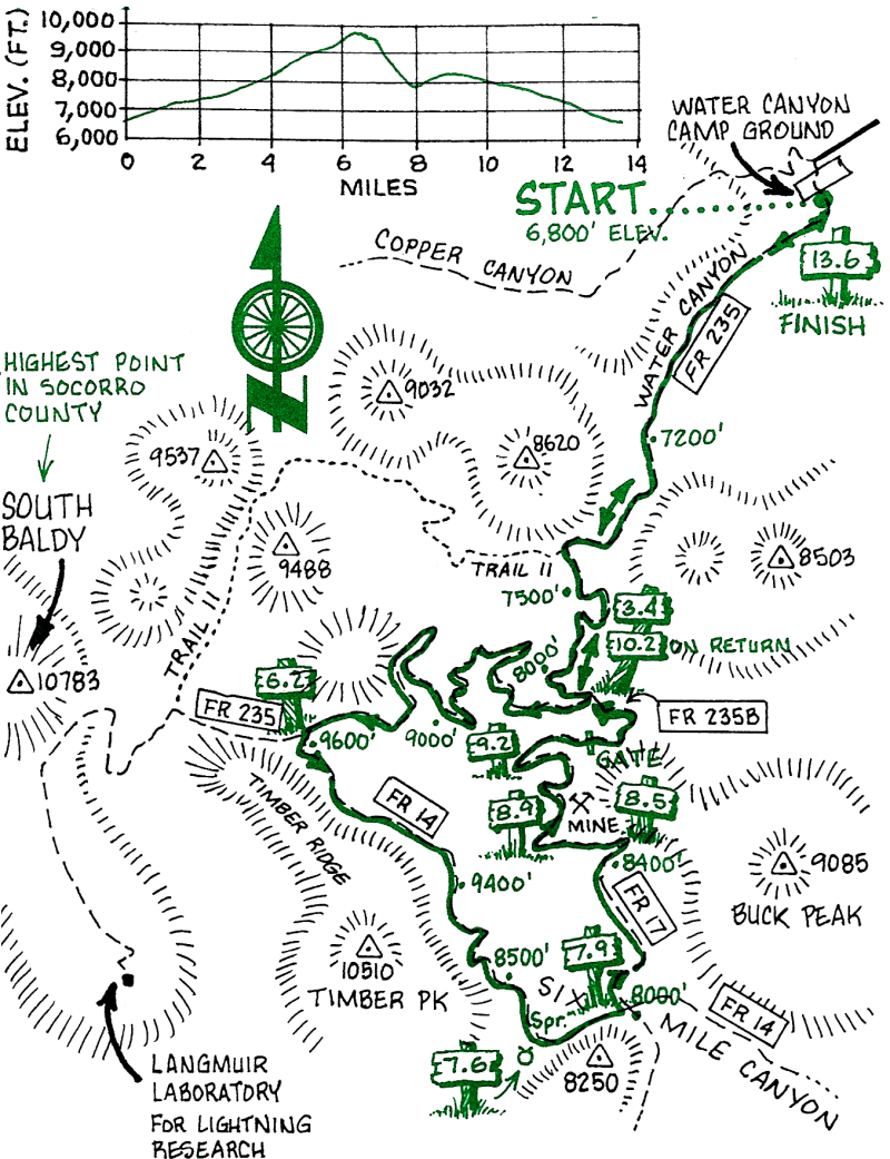
Note that this is a very active lightning area during a thunderstorm. Though rain storms are generally brief, they can be torrential and usually occur in mid-to-late afternoon in July and August.
Six-Mile Canyon is so-named because it's about six miles southwest of Socorro.
| Mileage | Surface | Notes |
|---|---|---|
| 0.0 | DIRT | Water Canyon Campground. Go across the stream (which will be dry at most times of year), and head up hill on Forest Road 235 toward Langmuir Laboratory for Atmospheric Research, operated in July and August by New Mexico Tech to study summer thunderstorms. |
| 3.4 | DIRT | Intersection of Forest Road 2358 (this is where you will re-enter the main road on the route back). Continue on the main road: don't turn. |
| 6.2 | DIRT | Sign for Six-Mile Canyon, Trail #14. Push your bike several hundred feet uphill to find the start of the single-track. |
| 7.6 | DIRT | Spring (don't drink the water). |
| 7.9 | DIRT | Junction of Trail #14 and Trail #17. Our route goes north on Trail #17. (It is possible to continue down Six-Mile Canyon, but much carrying and pushing of bikes is required. Once we went south here and down Ryan Hill Canyon, but the trail didn't exist in many places, and it left us 18 miles west of San Antonio.) |
| 8.0 | DIRT | The trail climbs steeply to the north. |
| 8.5 | DIRT | This is the top of the hill. |
| 8.9 | DIRT | Mining area. The single-track becomes an old mining road. |
| 9.2 | DIRT | South Canyon Stream. There is water here in the spring, but it may be dry later in the year. |
| 9.9 | DIRT | Go under the gate (you may need to dismount for this maneuver). |
| 10.2 | DIRT | Junction with Forest Road 235 (this is the point you noted at mile 3.4). It's all down-hill now---well, mostly. |
| 13.6 | DIRT | Water Canyon Campground. It's a lot cooler here than it will be back in Socorro! |