|
Magdalena Mountains Trail 11 |
 |
|
|
Magdalena Mountains Trail 11 |
|
|
|
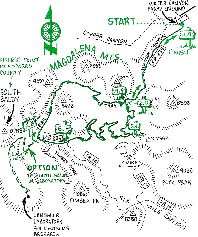
The first 6.6 miles up Forest Road 235 has an elevation gain of over 2,000 ft. The next 3.3 miles (Trail 11) is a single-track descent, steep at times.
Although not included in this mileage log, you might be interested in following FR 235 to its end (about 10 miles from the Campground) at the top of the Magdalena Mountain range, where you can visit Langmuir Laboratory for Atmospheric Research (10,600 ft.). The Lab, which is operated by New Mexico Tech for studies of thunderstorms and cloud electrification processes, is open to the public in July and August. During other times of the year the Laboratory is closed and the last mile of the road is not open to motor vehicles. During the late summer, visitors to the mountain top should be aware that thunderstorms are a common occurrence here and may pose a danger to bicyclists and hikers. Heavy local rainstorms may also be followed by flash floods in the drainages, and by road and trail wash-outs.
The drainage from Water Canyon provided water for A T&SF engines on the railroad spur between Magdalena and Socorro, operated after the 1890s for shipping cattle to market. Today the Campground serves as a favorite recreational area for families from Socorro and Magdalena.
The U.S. Forest Service Ranger Station in Magdalena can provide maps showing the many roads and trails in the Cibola National Forest's Magdalena and San Mateo Mountains that are suitable for hiking and mountain biking.
| Mileage | Surface | Notes |
|---|---|---|
| 0.0 | DIRT | From Water Canyon Campground, head south across the creek (which may be dry) on Forest Road 235. Head up the mountain. |
| 2.0 | DIRT | You pass the bottom of Trail 11. This is where you will emerge on the return trip. |
| 6.1 | DIRT | Trail 14. (It's rideable down Six-Mile Canyon to Highway 60, but not part of this ride.) |
| 6.6 | DIRT | Trail 11. Lower your seat: the first 200 yards are steep. There is a pretty meadow at the bottom of the steep part. This single track continues down the mountain for the next 3.3 miles. |
| 9.9 | DIRT | Back to Forest Road 235. Follow it back down to.. |
| 11.9 | DIRT | ... Water Canyon Campground. |