|
South Baldy to North Baldy and Jordan Canyon |
 |
|
|
South Baldy to North Baldy and Jordan Canyon |
|
|
|
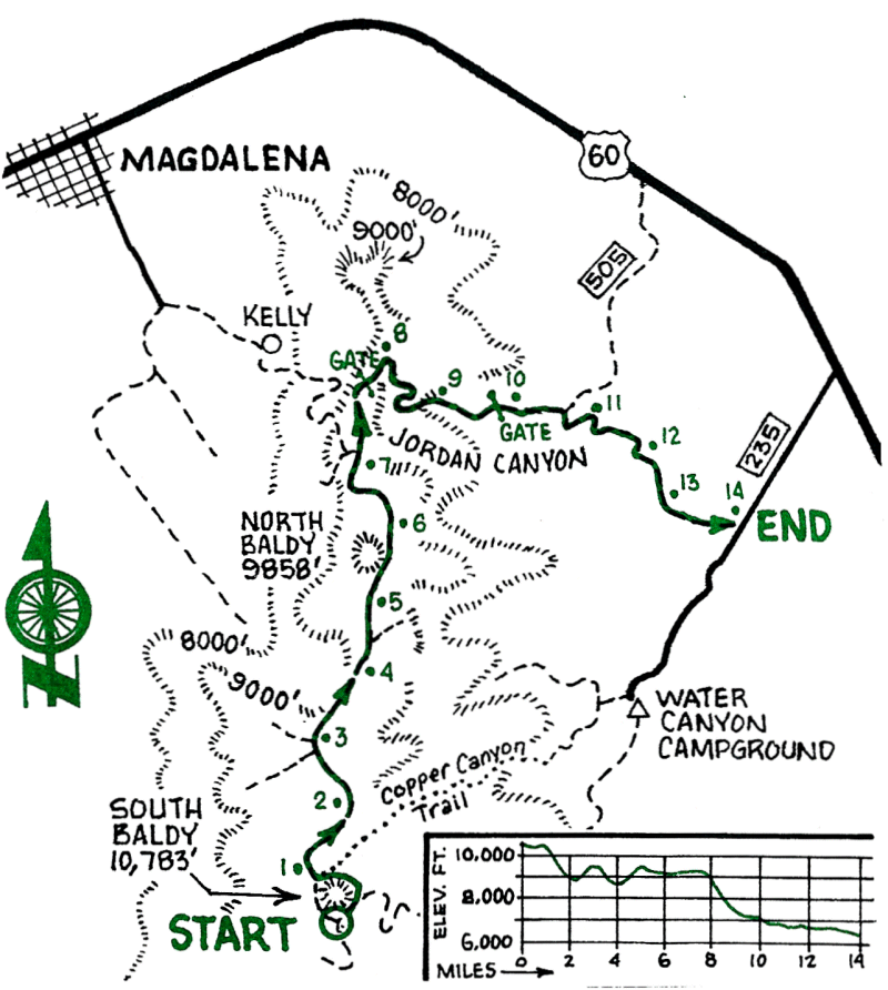
This is a high-altitude ride following single-track Trail 8 along the crest of the Magdalena range from South Baldy to North Baldy. Only about two-thirds of T-8 can be ridden, so be prepared for some bike pushing and carrying. The descent down Jordan Canyon is steep, rugged, loose and very difficult. Alternative descents can be made down Hop Canyon Trail at mile 2.9 (see ride #23, HOP CANYON) or down FR 190 to the ghost town of Kelly at mile 7.1.
| Mileage | Surface | Notes |
|---|---|---|
| 0.0 | TRAIL | Start of Trail 8 on FR 235, a quarter of a mile below the South Baldy gate to Langmuir Laboratory. Climb on T-8 and cross the east ridge of South Baldy, then carry on around South Baldy slowly losing height. |
| 0.4 | TRAIL | Junction with north ridge of South Baldy. Continue north on T-8 which runs down along the west side of the ridge and soon reaches some meadows. |
| 0.9 | TRAIL | Junction with Copper Canyon trail. Continue north on T-8. |
| 1.9 | TRAIL | Kempton's gold mine and access road. Continue north on T-8 which here runs on the east side of the ridge. |
| 2.7 | TRAIL | Junction with Mill Canyon trail. Continue on T-8. |
| 2.9 | TRAIL | Do not take the Hop Canyon trail. Stay on T-8 which here turns to the right. The trail drops for 300 yards, then climbs steadily and becomes rocky. |
| 4.5 | TRAIL | Poorly marked trail coming up from the right. Stay on T-8 and start a long push up through the white cliffs. |
| 4.9 | TRAIL | Follow cairns as T-8 turns right. |
| 5.3 | DIRT | End of T-8. Ride ahead along the dirt road with North Baldy on your left. |
| 5.5 | DIRT | The north ridge of North Baldy. This is a good place to stop and walk up to the top of North Baldy for an excellent view. After returning to your bike, ride north along the road. |
| 6.2 | DIRT | North Baldy T-8 sign on road. |
| 6.9 | DIRT | Road forks. Stay on the left fork which drops before continuing along the ridge. |
| 7.1 | DIRT | Four-way crossroad. The road to the left is FR 190 which descends to Kelly. Go straight through the crossroad to take the road which heads north along the ridge. |
| 7.3 | DIRT | Excellent quartz crystals on right-hand side of road. |
| 7.6 | DIRT | "Road Closed" sign on gate across the road. Go through. |
| 7.7 | DIRT | Road forks. Take the right (lower) fork. You are now on the Jordan Canyon road. Ride carefully down the steep, rugged road passing several mining areas and old shacks along the way. |
| 9 8 | DIRT | Gate across the road. Go through. |
| 10.7 | DIRT | Junction with FR 505 at abandoned ranch. Turn right (east) on FR 505. |