|
Jordan Canyon - North Baldy - Kelly |
 |
|
|
Jordan Canyon - North Baldy - Kelly |
|
|
|
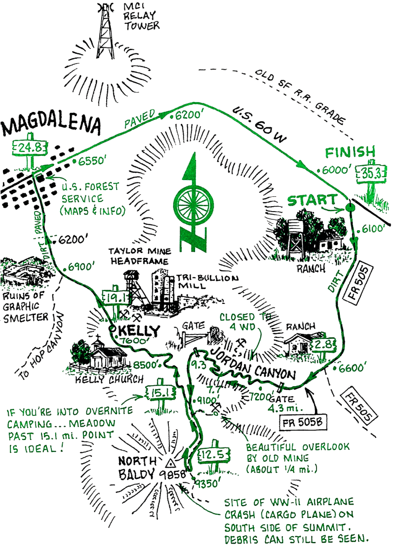
We think this is the most challenging ride in the book. It ascends the northmost ridge of the Magdalena Mountains to a high peak with extensive views. On the descent, the route goes past the ghost town of Kelly, whose mines were responsible for Magdalena's heyday at the turn of the century.
Kelly was originally the site of a sawmill and a lead-zinc mine. The town of 3,000 was laid out in 1870. Silver was mined in the 1880s, and the community was sustained by zinc recoveries into the 1930s. The smelter area, west of town, was dismantled and moved to southern New Mexico in the 1950s.
The Magdalena Post Office has been in operation since 1880. The town served as the eastern terminus of annual cattle drives from eastern Arizona and western New Mexico. A railroad spur from Socorro, built for shipping cattle, is visible today only as the remnants of the railbed. The old railroad station now houses City Hall for the Village of Magdalena.
| Mileage | Surface | Notes |
|---|---|---|
| 0.0 | DIRT | Ride up FR 505. gaining elevation and passing from grassland to pinion-juniper country. |
| 2.8 | DIRT | An old homestead marks the junction of FR 505A and 505B. Take the right fork (505A), and proceed into Jordan Canyon. |
| 4.3 | DIRT | The road takes the north (right) fork of the canyon and becomes steeper and more rocky (prepare to push!): water may be found here during wet times of the year. Pass through a gate and later past an old mining checkpoint. |
| 7.7 | DIRT | The road begins to switch back as it climbs to the crest. |
| 9.3 | DIRT | This is the Magdalena crest at 9,000 ft. Pass through the other end of the road closure and proceed south along the crest, which opens up into a park-like landscape of Ponderosa pines, with extensive views of the San Mateo mountains and the town of Magdalena to the west and NW. A few old mines are visible along this road. As you pedal along the refreshingly gradual crest, be sure to note in passing the clearly "major" road to the west which descends to Magdalena: this will be your way down. A little over a mile before the summit, the crest road officially turns into a trail in a meadow, where a sign indicates the trail to North Baldy. Carrying your bike over the road closure berms (or pedaling around them to the right), you come to the last few steep climbs and reach the end of the road. |
| 12.5 | DIRT | Park your bike at the high point of the road and scramble up the last few feet of North Baldy's grassy east ridge for a spectacular 360 view of central New Mexico (if the weather is cooperative), stretching from the Sandias to Mt. Taylor, to Sierra Blanca. To the west, on the Plains of St. Agustin, those white things that look like enormous golf tees are the antennas of the Very Large Array radio telescope. To return, proceed back (north) along the Magdalena crest approximately 2.6 miles to the junction. |
| 15.1 | DIRT | Junction of the Magdalena Road. Take it for a screaming descent down the west slope of the ridge. |
| 19.1 | DIRT | Having just lost 1,700 ft. of elevation, you are now at the ghost town of Kelly, the former mining lifeblood of Magdalena. The sole maintained building here is a small white church. Ruins and assorted detritus from the late 19th and early 20th century lie scattered uphill from the church. Continue pedaling downhill for another 5.7 miles on a well-graded, and eventually paved road toward Magdalena. |
| 24.8 | PAVED | Intersection of Highway 80, the main thoroughfare of Magdalena. If you're dying for some carbos, be sure to stop at Evett's Cafe on the N side of Highway 60 (look at the historic photos of Kelly on the wall). Proceed along the shoulder of the highway heading east toward Socorro for 10.5 mostly-downhill miles back to your starting point. |
| 35.3 | PAVED | Back to the turnoff of Forest Road 505, where your car is parked. |