|
Gallinas Canyon Ruins |
 |
|
|
Gallinas Canyon Ruins |
|
|
|
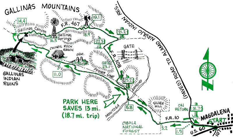
This beautiful ride in pinion pine forest and grassy meadows in the Cibola Forest NW of Magdalena begins on reasonably good forest gravel roads that become more difficult dirt 4-WD roads. All Forest Roads are marked and numbered. The highlight of the trip is the ride down the floor of Gallinas Canyon with a visit to the Gallinas Canyon Indian Ruins. The ruins are now mostly overgrown rock mounds, but room outlines and the results of some excavation and stabilization can be seen. Please respect our cultural heritage and do not disturb the site. To make the shorter 18.7 mile trip, drive to the 6.5 mile mark and start the ride at the junction of FR 10 and 10B.
In 1881, two prospectors by the names of White and Davis found some silver in the Gallinas Mountains, where they located their Old Boss Mine. Due to the recent silver discovery in the Iron Mountains near Socorro, this claim generated much excitement. By October 1881, a town site had started and was named Council Rock after a nearby rock formation made famous as a meeting place for peace talks between Indians and the white man. Real estate promoters sold lots, built cabins, and started a town, but the mines failed to produce sufficient silver to support the town. The Post Office was closed in early 1883 and it quickly slipped into obscurity. A few ranches remained in the area, one of which you pass by on the trail. A cemetery from the brief town site and the Council Rock ranches is atop the hill just east of the present day Council Rock Ranch.
Not much is known about the Indians who built some modest dwellings in Gallinas Canyon. The foundation ruins are being stabilized by the Bureau of Land Management for future study.
| Mileage | Surface | Notes |
|---|---|---|
| 0.0 | PAVED | Magdalena. Junction of Highway 60 and Route 169 (52 on older maps), at the west end of town. Head west on Rt. 169. |
| 1.5 | DIRT | Turn left on Forest Road (FR 10). |
| 3.2 | DIRT | Cibola National Forest boundary. |
| 5.8 | DIRT | FR 10 crosses Montosa Arroyo. |
| 6.5 | DIRT | Junction with FR 10B on the right. This is the point at which you will return to FR 10 on the return trip. Continue west on FR 10 (the left fork). |
| 11.0 | DIRT | Council Rock Ranch. FR 10 becomes FR 10W. Go west on 10W. |
| 14.1 | DIRT | Junction with FR 467. a dirt 4-WD road. The climbing is now mostly over. Turn right on FR 467. |
| 14.4 | DIRT | The floor of Gallinas Canyon. There is usually not water running in the canyon. Turn right and follow the easiest route down the canyon (FR 467 may have been washed out by flooding). |
| 14.5 | DIRT | Gallinas Canyon Ruins, mainly on the right side of the canyon. After exploring, continue down the canyon. |
| 16.5 | DIRT | Gallinas Spring windmill on right, and a fence across the arroyo. Cross the fence and continue down the canyon. |
| 18.9 | DIRT | "Gallinas Canyon" sign on left bank of the arroyo. |
| 19.1 | DIRT | Ake windmill and corral on left and fence across the arroyo. Cross the fence and continue down the canyon. |
| 19.2 | DIRT | FR 467 exits the arroyo on the right about 40 yards above the confluence of Gallinas Canyon with McGee Canyon. Turn right on FR 467 and enjoy the panorama of the Magdalena Range. |
| 21.2 | DIRT | Turn right on FR 10B. |
| 22.3 | DIRT | Junction with FR 10BD. Stay on FR 10B. After this point, FR 10B degrades into a poor 4-WD road difficult to follow because of intersecting trails. All major junctions on FR 10B are marked. |
| 23.1 | DIRT | Gate across the road. |
| 24.4 | DIRT | Junction with FR 1066. Stay on FR 10B. |
| 25.2 | DIRT | Junction with FR 10. Return to Magdalena by your outward route. |
| 31.7 | DIRT | Junction of Highway 60 and Rt. 169. |