|
Morine and Durfee Canyons |
 |
|
|
Morine and Durfee Canyons |
|
|
|
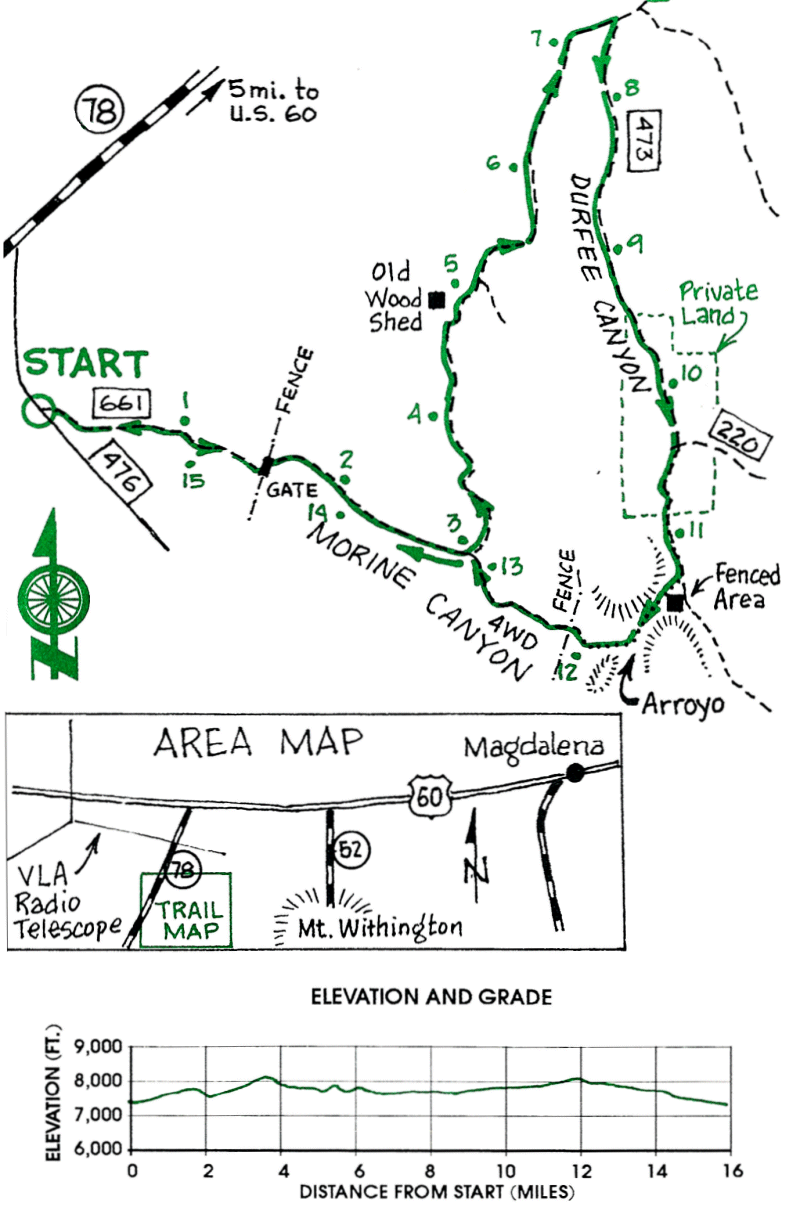
This is an excellent ride with a variety of terrain including wooded canyons, open rangeland and high mountain passes. There are beautiful views of the Plains of San Agustin and the VLA Radiotelescope from the hills above Durfee Canyon.
| Mileage | Surface | Notes |
|---|---|---|
| 0.0 | DIRT | Junction of FR 661 and FR 476. This point is 1.2 miles up FR 476 from NM 52 (NM 78). Ride east up FR 661. |
| 1.7 | DIRT | Gate. Go through. |
| 2.1 | DIRT | Morine Canyon. Continue up FR 661. |
| 3.0 | DIRT | Road junction. Ride left (north) up the road which leaves Morine Canyon. Your return route will be down the road which continues up Morine Canyon at this point. |
| 3.6 | DIRT | Top of hill at 8120 ft., after a steep climb. |
| 4.9 | DIRT | Wood shed on the left. |
| 5.1 | DIRT | Side road on right in an arroyo. Stay on main road to left (north). |
| 6.5 | DIRT | Excellent views of the Plains of San Agustin to the north. |
| 7.0 | DIRT | Road curves to the right down into Durfee Canyon. |
| 7.4 | DIRT | Durfee Canyon. Turn right up the canyon on FR 473. |
| 10.5 | DIRT | FR 220 joins from left. Continue up canyon (south). |
| 10.9 | DIRT | Leave private land. |
| 11.4 | DIRT | Fenced enclosure on right. On north side of the enclosure push your bike west about 100 yds and pick up the faint remains of an old logging road which heads west into an arroyo. Ride up the road which has numerous mounds of dirt across it to prevent use and erosion. |
| 11.7 | DIRT | Large rock outcrop on left side of arroyo. Continue up road which climbs steeply. |
| 12.1 | DIRT | Road ends on flat saddle between Durfee and Morine Canyons. Continue across country in a NW direction and find a fence. |
| 12.2 | DIRT | Fence. Cross fence and follow it down to the left for about 100 yds to the lowest point where it crosses an arroyo. This is the head of Morine Canyon. By the fence, on the south side of the arroyo are two old roads. Follow the lower one down Morine Canyon. |
| 13.1 | DIRT | Back at junction with FR 661. Ride down to car. |
| 16.1 | DIRT | Junction of FR 661 and FR 476. |