|
Mt. Withington |
 |
|
|
Mt. Withington |
|
|
|
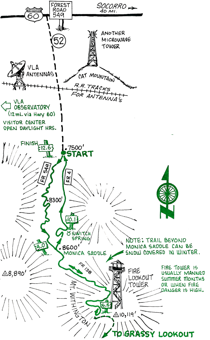
This ride involves some steep climbing up a Forest Service road. Note that the upper sections of this ride are typically covered by snow until late April. During the summer monsoon, usually in July and August, watch for late afternoon or evening thunderstorms.
| Mileage | Surface | Notes |
|---|---|---|
| 0.0 | DIRT | From the junction of FR 549 and FR 4, ride up FR 549 to Monica Saddle. Note the closed road (old FR 4) descending just to the east of FR 549 when you get to the saddle. This will be your descent. |
| 4.0 | DIRT | Monica Saddle. Turn left onto FR 138. The road climbs fairly steeply on a few spots, but also contains some beautiful level sections with extensive views to the southwest. Vegetation changes from pinion, juniper, and scrub oak to Douglas fir and aspen. |
| 6.5 | DIRT | Summit of Mt. Withington (10,119 ft.). The view from the fire tower is one of the best in the country, stretching from the Gila Wilderness to Mt. Taylor. To the NW, the dishes of the Very Large Array can be seen. Ambitious parties can put in an additional 18 miles here by continuing south along FR 138 to Big Grassy Lookout and back to Withington.) Descend on FR 138 back to the Saddle. |
| 9.0 | DIRT | Monica Saddle. Turn down old FR 4 (past the "Road Closed" gate). The first 3/4 mile is fairly steep and rocky. Watch out for washed-out sections and downed trees! |
| 10.1 | DIRT | Switch Spring and the beginning of the maintained section of FR 4 (you will pass a "Road Closed" gate just before the Spring). From here it's a gentle downhill ride until just before the junction of FR 549 and FR 4, where the road briefly climbs back up to the junction. |
| 12.6 | DIRT | Junction of FR 549 and FR 4. |