|
Big Rosa Canyon |
 |
|
|
Big Rosa Canyon |
|
|
|
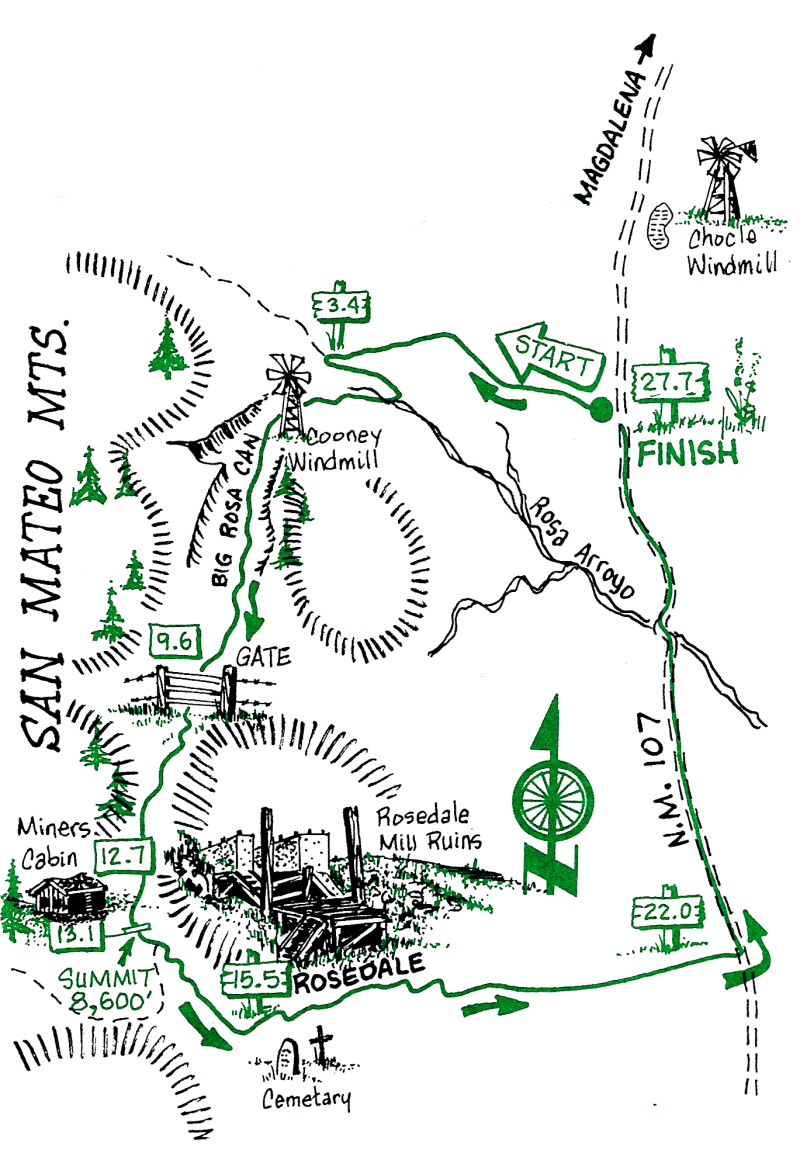
This beautiful ride starts on a lightly-used Forest Service road that soon drops into a canyon bottom filled with wildflowers, a variety of trees, occasional streams, and wildlife. The ride up the canyon follows an old road used originally by miners and later by loggers. At the 9.6 mile point the road is closed to motor vehicles; the area to the west is wilderness (no bikes). After leaving the canyon, there is a short single-track ascent and a long, steep descent into the ghost town of Rosedale---an excellent lunch stop while you visualize what it must have been like a century ago. The remainder of the ride back to the car is through open range dotted with cattle and antelope.
Rosedale was the site of gold discovery by Jack Richardson in the 1880s. The town was named after a lady friend. The Rosedale Mining and Milling Company burned in 1910, but the holdings were subsequently leased and operated for some time. The Post Office, established in 1899, was closed in 1928.
| Mileage | Surface | Notes |
|---|---|---|
| 0.0 | DIRT | Elevation 6,400 ft. Park at the intersection of State Road 107 and Forest Road 52, and head northwest on the Forest Road. |
| 3.4 | DIRT | Elevation 7,000 ft. Turn left onto Forest Road 56 and head down into Big Rosa Canyon. |
| 9.6 | DIRT | Elevation 7,200 ft. Continue up the canyon and through the iron gate on Trail 36. The road to the right goes up Water Canyon which soon enters the Wilderness Area. A beautiful area for a hike, but don't head in that direction now. |
| 12.7 | DIRT | An old miner's cabin on the right makes a good rest stop. |
| 12.9 | DIRT | Elevation 8,400 ft. The ride continues straight ahead, up the single track, Trail #92. The next 0.2 mile can be ridden by the strong, or pushed by the rest of us. Big Rosa Canyon goes to the right and comes out on the Crest Road. |
| 13.1 | DIRT | Elevation 8,600 ft. You have reached the divide of this ride. An old Forest Service trail leads off to the right to Grassy Lookout (don't go that way). From here the ride is predominantly downhill---especially the next 0.5 mile. |
| 13.3 | DIRT | Elevation 8.086 ft. The single track meets Forest Road 330; go down hill to Rosedale. |
| 15.5 | DIRT | Elevation 7,200 ft. On the left and right are remnants of the town of Rosedale. This is a good break place, so you can explore the ghost town and the mines. Continue east on Forest Road 330. |
| 22.0 | DIRT | Turn left (north) at the intersection of State Road 107. |
| 27.7 | DIRT | You're back at your car, after a most interesting and aerobic ride. |