|
Riley Loop |
 |
|
|
Riley Loop |
|
|
|
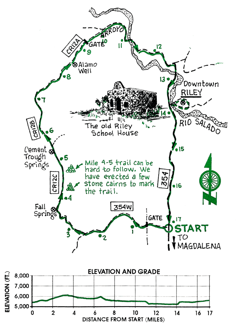
This scenic loop takes the rider through the northern Bear Mountains, down Canyon del Alamito to the Rio Salado and the ghost town of Riley. The ride offers an interesting variety of terrain including volcanic badlands, rugged mountains, and soft arroyos.
| Mileage | Surface | Notes |
|---|---|---|
| 0.0 | DIRT | Junction of FR 354 and FR 354W. (FR 354W is marked as FR 354E on the USFS map.) Ride west on FR 354W. |
| 0.7 | DIRT | Cross Baca Canyon and go through the gate, closing it behind you. |
| 1.9 | DIRT | Stay on FR 354W which exits right (northwest) out of the arroyo. |
| 2.3 | DIRT | Turn right (northwest) onto FR 354WA and climb through colorful volcanic hills. |
| 3.3 | DIRT | Road becomes FR 12C in Canyon del Tanque Hondo. Ride down FR 120 to Fall Spring. |
| 3.5 | DIRT | Road exits steeply left (north) out of the canyon just beyond the water tank. The road is difficult to follow in places for the next 3.7 mi. Be sure to find the next six checkpoints to ensure that you are on the correct route. |
| 5.2 | DIRT | FR 12C drops into an arroyo. Turn left up the arroyo and after 100 yards exit the arroyo on FR 120 to the right (north). |
| 5.5 | DIRT | Ruins of a stone house. |
| 5.6 | DIRT | Cement Trough Spring. The road becomes FR 12B by the metal water tank. |
| 6.0 | DIRT | Poorly defined fork in the road. Stay to left (northwest). |
| 6.8 | DIRT | Road crosses over a saddle. View of Mount Taylor is to the north. |
| 7.2 | SAND | Canyon del Alamito. Turn right down canyon which is soft in places. |
| 9.2 | SAND | Gate across arroyo. Go through and continue down arroyo. |
| 9.5 | DIRT | Road leaves arroyo on right (east) side. |
| 10.5 | DIRT | Junction with FR 12. |
| 11.1 | DIRT | Road crosses Rio Salado. |
| 12.6 | DIRT | Turn right towards river. |
| 12.8 | DIRT | Road crosses Rio Salado. |
| 13.8 | DIRT | A side road on the left leads to Riley ghost town and its church, Santa Rita. Take the 04-mi. side trip to Riley across the Rio Salado, or continue straight ahead through the ranch cattle guards on FR 354 towards your car. |
| 15.1 | DIRT | USFS boundary. |
| 17.0 | DIRT | Junction with FR 354W. |